Discover Florida Nature
It's time to explore the natural Florida

|
|
|
|
|
 Florida
is 500 miles long and 160 miles wide at its most distant points. The
geographic center of Florida is located in Hernando County, 12 miles NNW
of Brooksville, with a Longitude of 81° 37.9'W and a Latitude of 28°
8.0'N. Florida covers 65,758 square miles, making it the 22nd largest
of the 50 states. 53,997 square miles of Florida are land areas,
leaving 11,761 square miles of Florida covered by water. It is the
third wettest state, with only Alaska and Michigan having more water!
Florida is 500 miles long and 160 miles wide at its most distant points.
Florida is bordered by Georgia and Alabama to the north. On the west
Florida is bordered by Alabama and the Gulf of Mexico. To the south and
to the east, Florida is surrounded by the Atlantic Ocean. Florida
is 500 miles long and 160 miles wide at its most distant points. The
geographic center of Florida is located in Hernando County, 12 miles NNW
of Brooksville, with a Longitude of 81° 37.9'W and a Latitude of 28°
8.0'N. Florida covers 65,758 square miles, making it the 22nd largest
of the 50 states. 53,997 square miles of Florida are land areas,
leaving 11,761 square miles of Florida covered by water. It is the
third wettest state, with only Alaska and Michigan having more water!
Florida is 500 miles long and 160 miles wide at its most distant points.
Florida is bordered by Georgia and Alabama to the north. On the west
Florida is bordered by Alabama and the Gulf of Mexico. To the south and
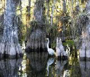
to the east, Florida is surrounded by the Atlantic Ocean.The Mean Elevation of the state of Florida is only 100 feet above sea level. Florida's highest peak is Britton Hill, found in Lakewood Park in Walton County, in the Florida panhandle. Although it is Florida's highest peak, it is only 345 feet above sea level. Florida lowest spot is at sea level and can be found all along both the Gulf coast and the Atlantic Ocean coast. The land of swaying palm trees and warm ocean breezes is quite flat with a rolling landscape to its highest point in the Northwest. Part of three geographic land areas make up the Florida landscape; the Atlantic Coastal Plain, the East Gulf Coastal Plain and the Florida Uplands. Atlantic Coastal Plain: The Atlantic Plain stretches from Cape Cod, Massachusetts south and around the Florida Peninsula and the Gulf of Mexico. A part of the Atlantic Plain, the Atlantic Coastal Plain completely covers the entire eastern part of Florida. The landscape is low and level and varies from about 30 to 90 miles wide. Off the mainland is a narrow strip of sand bars, coral reefs and barrier islands. Most of southern Florida, 2,746 square miles, is covered by the Big Cypress Swamp and the Florida Everglades. This area is saturated with water, especially during the rainy months. To the south of the mainland, lie the Florida Keys curving out to sea about 150 miles in a southwesterly direction. The largest island of this chain of islands is Key Largo. East Gulf Coastal Plain: The East Gulf Coastal Plain, a sub-section of the Atlantic Plain, like the Atlantic Coastal Plain, presents itself in two sections of Florida. The sections are divided by a portion of the Florida Uplands. In southwestern Florida, the East Gulf Coastal Plain extends inland to cover parts of the Big Cypress Swamp and the Everglades. The East Gulf Coastal Plain is similar to the Atlantic Coastal Plain on the other side of the Florida peninsula. Barrier islands run along the west coast of Florida and coastal swampland extends inland. The northern section of the East Gulf Coastal Plain curves around the upper edge of the northeastern Gulf of Mexico at Apalachee Bay and extends west across the Florida panhandle to Florida's western border. Florida Uplands: From the northwest corner of the state, the Florida Uplands run about 275 miles west to east, along the northern edge of the Florida Panhandle and then extends south into the central area of the Florida peninsula. The width of the northern Florida Uplands varies from around 30 to 50 miles and is characterized by low rolling hills of red clay. Hard and softwood forests are plentiful. The section of the Florida Uplands that extends south into the peninsula, covers an area about 100 miles wide and 160 miles long. This area extends from the north, south and to the east, to separate the two sections of the East Gulf Coastal Plain and to separate the East Gulf Coastal Plain from the Atlantic Coastal Plain. The landscape in the southern Florida Uplands is characterized by low hills and many lakes. Though the Florida Uplands are only 200-300 feet above sea level, they are still higher than the regions of the Atlantic Coastal Plain and the East Gulf Coastal Plain. The highest point in Florida is found in the Florida Uplands that run along the northern edge of the panhandle. Just south of the Alabama border, west of Paxton, Britton Hill is 345 feet above sea level and is the lowest state high point in the nation. Florida Everglades- The Florida Everglades, located in southern Florida, is one of the largest wetlands in the world. The Everglades is actually a shallow, slow-moving, freshwater river nearly 50 miles wide! At its head is 700 square mile Lake Okeechobee. The Lake Okeechobee-Everglades Basin covers nearly 17,000 square miles. Overflow from Lake Okeechobee together with rain water accumulated along the way flows slowly to the sea. Within this "river of grass" are are vast expanses of sawgrass prairies populated with sporadic stands of tropical hardwood hammocks. This seemingly endless sea of grass and "swamp" is occupied by the American alligator and crocodile, otters, the magnificent Florida panther, bobcats, roseate spoonbills, ospreys, snowy egrets, great blue herons, dozens of species of reptiles, and many mammal species. Hundreds of kinds of fish and over three hundred varieties of birds also make the Everglades their home. Small hammocks of raised vegetation that frequently include palms, pine, live oaks, gumbo-limbo trees, and cypress are like little islands in this sea of grass. Everglades National Park, established in 1947 to protect this fragile environment, represents only a portion of the Lake Okeechobee-Everglades Basin. Still, this national park covers over one and a half million acres of aquatic wilderness. |
|
|
Advertise | Privacy Statement | Dog Encyclopedia | Video |Contact | Alaska Nature |
|