Discover Florida Nature
It's time to explore the natural Florida

|
|
|
|
|
|
What is a hurricane? A hurricane is a type of tropical cyclone, which is a generic term for a low pressure system that generally forms in the tropics. The cyclone is accompanied by thunderstorms and, in the Northern Hemisphere, a counterclockwise circulation of winds near the earth's surface. The ingredients for a hurricane include a pre-existing weather disturbance, warm tropical oceans, moisture, and relatively light winds aloft. If the right conditions persist long enough, they can combine to produce the violent winds, incredible waves, torrential rains, and floods we associate with this phenomenon. When is hurricane season? The Atlantic hurricane season is officially from June 1st to November 30th. What is the difference between a hurricane watch and a hurricane warning? A watch means Hurricane/tropical storm conditions are possible in the specified area, usually within 36 hours. Tune in to NOAA Weather Radio, commercial radio, or television for information. A warning means Hurricane/tropical storm conditions are expected in the specified area, usually within 24 hours. What is a "Cape Verde" hurricane? Cape Verde-type hurricanes are those Atlantic basin tropical cyclones that develop into tropical storms fairly close (<1000 km [600 mi] or so) of the Cape Verde Islands and then become hurricanes before reaching the Caribbean. Typically, this may occur in August and September, but in rare years (like 1995) there may be some in late July and/or early October. The numbers range from none up to around five per year - with an average of around 2. How do I convert from mph to knots or kilometers? 1 mile per hour = 0.869 international nautical mile per hour (knot) 1 mile per hour = 1.609 kilometers per hour For easier conversions try this unit converter What is a "CDO" ? 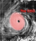 "CDO"
is an acronym that stands for "central dense overcast". This is the
cirrus cloud shield that results from the thunderstorms in the eyewall
of a tropical cyclone and its rainbands. Before the tropical cyclone
reaches hurricane strength (33 m/s, 64 kts, 74mph), typically the CDO is
uniformly showing the cold cloud tops of the cirrus with no eye
apparent. Once the storm reaches the hurricane strength threshold,
usually an eye can be seen in either the infrared or visible channels of
the satellites. Tropical cyclones that have nearly circular CDO's are
indicative of favorable, low vertical shear environments. "CDO"
is an acronym that stands for "central dense overcast". This is the
cirrus cloud shield that results from the thunderstorms in the eyewall
of a tropical cyclone and its rainbands. Before the tropical cyclone
reaches hurricane strength (33 m/s, 64 kts, 74mph), typically the CDO is
uniformly showing the cold cloud tops of the cirrus with no eye
apparent. Once the storm reaches the hurricane strength threshold,
usually an eye can be seen in either the infrared or visible channels of
the satellites. Tropical cyclones that have nearly circular CDO's are
indicative of favorable, low vertical shear environments.When are storms most likely to occur? Generally in the months of August, September and October, however there have been tropical and sub-tropical storms in every month. What parts of a tropical cyclone are most favored for tornado formation? In the northern hemisphere, the right-front quadrant (relative to TC motion) is strongly favored. In the southern hemisphere, the left-front quadrant presumably is favored, although there is little research on this point. Most of the tornadoes form in outer rainbands some 50-200 miles from the TC center, but some have been documented to occur in the inner core, or even in the TC eyewall. Why are tropical cyclones named? Tropical cyclones are named to provide ease of communication between forecasters and the general public regarding forecasts, watches, and warnings. Since the storms can often last a week or longer and that more than one can be occurring in the same basin at the same time, names can reduce the confusion about what storm is being described. What is the origin of the name "hurricane"? 'hurican' was derived from the Mayan 'Hurakan', one of their creator gods, who blew his breath across the Chaotic water and brought forth dry land. Why don't we try to destroy tropical cyclones? Actually for a couple decades NOAA and its predecessor tried to weaken hurricanes by dropping silver iodide - a substance that serves as a effective ice nuclei - into the rainbands of the storms. The idea was that the silver iodide would enhance the thunderstorms of the rainband by causing the supercooled water to freeze, thus liberating the latent heat of fusion and helping the rainband to grow at the expense of the eyewall. With a weakened convergence to the eyewall, the strong inner core winds would also weaken quite a bit. Neat idea, but it, in the end, had a fatal flaw: there just isn't much supercooled water available in hurricane convection! During a hurricane are you supposed to have the windows and doors on the storm side closed and the windows and doors on the lee side open? No! All of the doors and windows should be closed (and shuttered) throughout the duration of the hurricane. The pressure differences between inside your house and outside in the storm do not build up enough to cause any damaging explosions. (No house is built airtight.) The winds in a hurricane are highly turbulent and an open window or door - even if in the lee side of the house - can be an open target to flying debris. All exterior windows should be boarded up with either wooden or metal shutters. |
|
|
Advertise | Privacy Statement | Dog Encyclopedia | Video |Contact | Alaska Nature |
|