Discover Florida Nature
It's time to explore the natural Florida

|
|
|
|
|
|
A storm surge is a rise in the ocean as the result of strong winds from
a hurricane or other intense storm. This ocean water crashes onto the
land in a powerful surge. The storm surge combined with the heavy rain
that comes with the hurricane can cause dangerous flooding in low-lying
coastal areas, especially when a storm surge coincides with a high tide.
This flooding can be the most dangerous part of a hurricane, potentially
causing many deaths. The height of the storm surge is the difference
between the level of the ocean and the level that would have occurred
normally. A storm surge is usually estimated by subtracting the regular
high tide level from the observed storm tide - it can be 15 feet tall or
more in a very strong storm (Hurricane Opal (a
Category 3 storm)
caused storm surges up to 24 feet). Because much of the United States' densely populated Atlantic and Gulf Coast coastlines lie less than 10 feet above mean sea level, the danger from storm tides is tremendous. The level of surge in a particular area is also determined by the slope of the continental shelf. A shallow slope off the coast will allow a greater surge to inundate coastal communities. Communities with a steeper continental shelf will not see as much surge inundation, although large breaking waves can still present major problems. Storm tides, waves, and currents in confined harbors severely damage ships, marinas, and pleasure boats. The illustration above shows the Tampa/St Pete area with a category 4 hurricane hitting at high tide. This actually occurred during the "Great Gale of 1848". In this worst case scenario St Petersburg actually becomes two separate islands. The storm tide--the combination of the storm surge plus the 1 foot high tide--reaches as much as 27 feet above mean sea level (pink colors) near downtown Tampa (right-hand "maximum storm tide" image). The amount of inundation inland is controlled by the elevation of the land. Some of the inland regions near downtown Tampa being inundated by the 27-foot storm tide are at an elevation of 19 feet, so as much as 8 feet of inundation will occur at those locations (dark blue colors in the left-hand "maximum water depth" image) Slosh Model- SLOSH (Sea, Lake and Overland Surges from Hurricanes) is a computerized model run by the National Hurricane Center (NHC) to estimate storm surge heights and winds resulting from historical, hypothetical, or predicted hurricanes by taking into account: -Pressure -Size -Forward speed 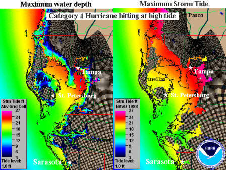 Track
Winds Graphical output (124kb or 348kb) from the model displays color
coded storm surge heights for a particular area in feet above the
model's reference level, the National Geodetic Vertical Datum (NGVD),
which is the elevation reference for most maps. The calculations are
applied to a specific locale's shoreline, incorporating the unique bay
and river configurations, water depths, bridges, roads and other
physical features. Track
Winds Graphical output (124kb or 348kb) from the model displays color
coded storm surge heights for a particular area in feet above the
model's reference level, the National Geodetic Vertical Datum (NGVD),
which is the elevation reference for most maps. The calculations are
applied to a specific locale's shoreline, incorporating the unique bay
and river configurations, water depths, bridges, roads and other
physical features.
If the model is being used to estimate storm surge from a predicted hurricane (as opposed to a hypothetical one), forecast data must be put in the model every 6 hours over a 72-hour period and updated as new forecasts become available. The SLOSH model is generally accurate within plus or minus 20 percent. For example, if the model calculates a peak 10 foot storm surge for the event, you can expect the observed peak to range from 8 to 12 feet. The model accounts for astronomical tides (which can add significantly to the water height) by specifying an initial tide level, but does not include rainfall amounts, river flow, or wind-driven waves. However, this information is combined with the model results in the final analysis of at-risk-areas. The point of a hurricane's landfall is crucial to determining which areas will be inundated by the storm surge. Where the hurricane forecast track is inaccurate, SLOSH model results will be inaccurate. The SLOSH model, therefore, is best used for defining the potential maximum surge for a location. If you have a Hurricane Evacuation Study (which combines SLOSH model results with traffic flow information), you do not need information about storm surge heights in a real hurricane situation. You will only need to know the forecast of the storm's intensity at landfall and the tide at that time to be able to make an appropriate evacuation decision. |
|
|
Advertise | Privacy Statement | Dog Encyclopedia | Video |Contact | Alaska Nature |
|